Qt QML API
Part of this project is libosmscout-client-qt library that aims to provide simple API for applications using user interface in QML.
This page show usage of basic QML components that may helps you create your own application with mapping capabilities, like displaying map, search places, routing… Following examples are using Silica UI components, but code for other UI components (like QtQuick components), will be very similar.
Initialisation
Before using library from QML it is necessary to initialise it from C++.
OSMScoutQt::RegisterQmlTypes();

bool success=OSMScoutQt::NewInstance()
     .WithBasemapLookupDirectory(basemapDir)
     .WithStyleSheetDirectory(stylesheetDir)
     .WithStyleSheetFile(stylesheetFileName)
     .WithIconDirectory(iconDirectory)
     .WithMapLookupDirectories(mapLookupDirectories)
     .WithOnlineTileProviders(":/resources/online-tile-providers.json")
     .WithMapProviders(":/resources/map-providers.json")
     .Init();

if (!success){
  // terminate program, or just report error - something is really bad

}

// now it is possible to create QML window that is using the library

// release resources

OSMScoutQt::FreeInstance();
For detailed description see OSMScoutQtBuilder class and practival usage OSMScout2 demo source code.
To make components awailable in QML, you have to import it:
import net.sf.libosmscout.map 1.0
Note: when you are writting application for Sailfish OS (SFOS) and do you plan to distribute
it via Harbour (official SFOS store), it is neccessary
to change component uri to match the name of the application:
OSMScoutQt::RegisterQmlTypes("harbour.<app-name>.map", 1, 0); Imported uri will be different
then, but another code will be working without change.
Displaying map
When you want to display a map, it is very simple. Just use Map UI component:
Map {
  id: map
  renderingType: "tiled" // plane (default) or tiled
}
For all signals and slots, see MapWidget. You can choose one of two rendering types:
- plane (default) - complete scene is re-rendered on every change of the view. Component may display partial (unfinished) rendering result, when rendering is not fast enough - it provides more responsive experience. This kind of rendering reduce rendering errors on tile boundary, but it don’t support combination of online tiles with offline rendering (yet). It fully supports map rotating, you can rotate map to device direction obtained from compass sensor.
- tiled - map is combined from tiles downloaded from some online web service (openstreetmap.org for example) and tiles rendered offline by library. This allows to render detailed map for whole world and keep benefits of offline rendering for areas covered by downloaded databases. It supports map rotating, but labels are rotated too. Rendering may be more responsive, due to tile caching in memory.
User input
Map component react on user touches with moving (or mouse drag) and zooming (multitouch gesture, double-click or scrolling of mouse wheel). Actions on simple click, or “holding” should be defined by application.
Map{
    onTap: {
        console.log("tap: " + screenX + "x" + screenY + " @ " +
                    lat + " " + lon + " (map center "+
                    map.view.lat + " " + map.view.lon + ")");
    }
    onLongTap: {
        console.log("long tap: " + screenX + "x" + screenY + " @ " +
                    lat + " " + lon + " (map center " +
                    map.view.lat + " " + map.view.lon + ")");
    }
}
Display custom marks and ways
Map component supports to display few kinds of overlay objects.
Current position mark
Just allow it by showCurrentPosition property
and update current position by locationChanged slot:
Map{
    id: map
    showCurrentPosition: true

    PositionSource {
        id: positionSource
        active: true
        onPositionChanged: {
            map.locationChanged(
                      position.latitudeValid && position.longitudeValid,
                      position.coordinate.latitude, position.coordinate.longitude,
                      position.horizontalAccuracyValid, position.horizontalAccuracy);
        }
    }
}
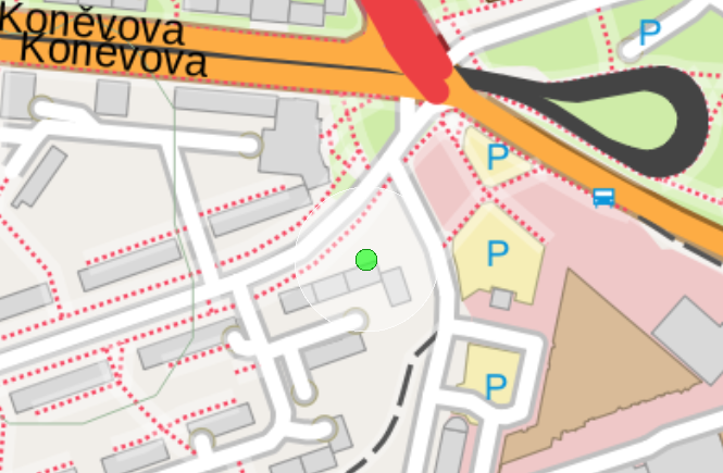
It will display small green dot (or red when position is not valid) with semitransparent circle representing horizontal accuracy:
Place mark
You can custom place mark by addPositionMark and remove it by removePositionMark.
Map{
  id: map
  property int markId: 0;
  onTap: {
      map.addPositionMark(markId++, lat, lon);
      if (markId>=10){
          map.removePositionMark(markId-10);
      }
  }
}
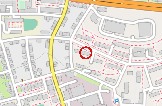
It will display red circle around position:
Custom way, area or node
This overlay type is used for displaying routing result for example, but it may be used for displaying any custom object with any style defined in stylesheet.
Map{
  property var overlayWay: map.createOverlayWay("_route");
  onTap: {
    overlayWay.addPoint(lat, lon);
    map.addOverlayObject(0, overlayWay);
  }
}
Overlay types that don’t exists in database, should be defined on library startup
by OSMScoutQtBuilder::AddCustomPoiType method.
Custom map overlays
For some kind of applications, custom map objects don’t cover all requirements.
For example when you want to display hill shades, traffic intensity or some kinds of heatmap,
you can create own QML component with MapOverlay
as base class and implement void paint(QPainter *painter) method to access full Qt rendering api.
Note: paint method is called in context of UI thread, execute CPU intensive tasks in
this thread will cause UI lags!
You can take inspiration in TiledMapOverlay
class that provides simple overlay based on online tile services.
For example pre-rendered hill shades.
Map {
  id: map

  TiledMapOverlay {
      anchors.fill: parent
      view: map.view
      enabled: true
      opacity: 0.6
      // If you intend to use tiles from OpenMapSurfer services in your own applications please contact us.
      // https://korona.geog.uni-heidelberg.de/contact.html
      provider: {
            "id": "ASTER_GDEM",
            "name": "Hillshade",
            "servers": [
              "https://korona.geog.uni-heidelberg.de/tiles/asterh/x=%2&y=%3&z=%1"
            ],
            "maximumZoomLevel": 18,
            "copyright": "© IAT, METI, NASA, NOAA",
          }
  }
}
QML overlay
There is also possible to use QML Canvas type for overlay. It is easy for proof of concept and may be suitable for some usecases.
Map {
id: map
Canvas {
id: mapCanvas
anchors.fill: parent
Connections {
target: map
onViewChanged: {
mapCanvas.requestPaint();
}
}
onPaint: {
try{
var ctx = getContext("2d");
ctx.clearRect(0, 0, mapCanvas.width, mapCanvas.height);
ctx.lineWidth = 4;
ctx.strokeStyle = "blue";
ctx.fillStyle = Qt.rgba(0, 0, 0.8, 0.2);
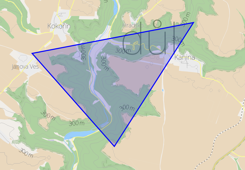
var p1 = map.screenPosition(50.4253, 14.5602);
var p2 = map.screenPosition(50.4099, 14.5816);
var p3 = map.screenPosition(50.4304, 14.6022);
ctx.beginPath();
ctx.moveTo(p1.x, p1.y);
ctx.lineTo(p2.x, p2.y);
ctx.lineTo(p3.x, p3.y);
ctx.closePath();
ctx.fill();
ctx.stroke();
}catch(e){
console.log("error: "+e);
}
}
}
}
Location info
LocationInfoModel provides description for place on map based on nearest POI object
or address point. It it usual Qt model that may be presented by some ListView.
LocationInfoModel {
    id: locationInfoModel
    Component.onCompleted: {
        locationInfoModel.setLocation(50.08923, 14.49837);
    }
}
SilicaListView {
    id: locationInfoView
    model: locationInfoModel
    delegate: Column{
        Label {
            id: entryPoi
            text: poi
            visible: poi != ""
        }
        Label {
            id: entryAddress
            text: address
            visible: address != ""
        }
    }
}
Possible result:
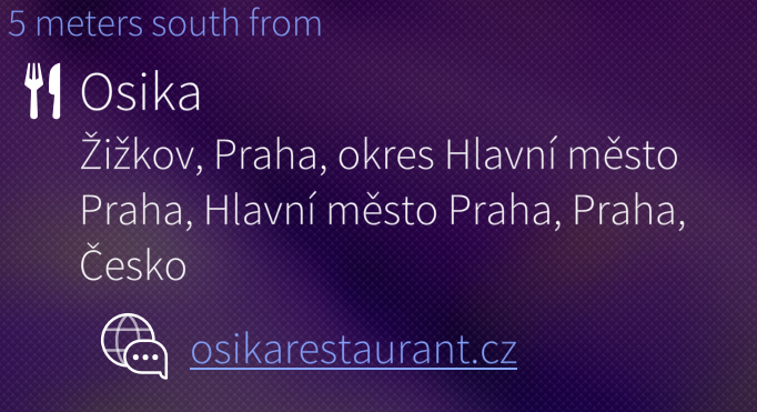
Detailed description in LocationInfoModel class.
Search place
LocationListModel provides search in location (address) index and “fulltext” index of named objects.
It is usual Qt model that may be presented by some ListView.
LocationListModel {
  id: suggestionModel
  Component.onCompleted: {
    suggestionModel.setPattern("Praha");
  }
}
SilicaListView {
  id: suggestionView
  model: suggestionModel
  delegate: Label {
    text: label
  }
}
Detailed description in LocationListModel class.
Search POI
NearPOIModel provide lookup of database objects (not limited to POI) by given coordinates and types.
It is usual Qt model that may be presented by some ListView.
NearPOIModel {
  id: poiModel
  lat: 50.0923
  lon: 14.4827
  maxDistance: 1000
  types: ["amenity_restaurant", "amenity_restaurant_building"]
}
SilicaListView {
  id: suggestionView
  model: poiModel
  delegate: Label {
    text: label
  }
}
Detailed description in NearPOIModel class.
Routing
RoutingListModel{
  id: route
  Component.onCompleted: {
    var from=route.locationEntryFromPosition(50.0920, 14.4936);
    var to=route.locationEntryFromPosition(49.1949, 16.6345);
    route.setStartAndTarget(from, to);
  }
  onComputingChanged: {
    if (route.count>0){
        console.log("route length: " + route.length + " m");
        console.log("route commands: " + route.count);
        map.addOverlayObject(0,route.routeWay);
    }
  }
}
Map{
  id: map
}
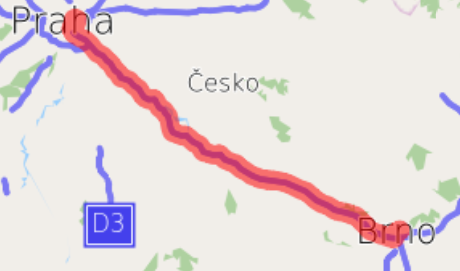
Detailed description in RoutingListModel class.
Behind the scene
Client Qt library consists from three layers:

QML components provides just limited set of capabilities now. But you may create your own data models or UI components easily. Just dive into source code and don’t worry to ask us on mailing list.